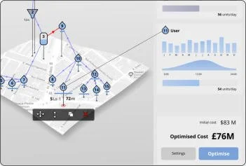
Aquaform is a software for water infrastructure design and monitoring. It enables engineers to design optimal water infrastructure and monitor its operation. It’s advanced mapping, infrastructure modelling and realtime optimisation functionality provides the tools needed to create detailed 3D models of water infrastructure, with realtime CAPEX and OPEX calculations. There are a wide range of applications of the software including greywater system design, realtime water monitoring and optimisation of industrial effluent treatment systems. Aquaform is built on a flexible software platform that can be reconfigured and optimised for new infrastructure projects.Introduction
Functionality
Mapping
Aquaform has a powerful mapping platform that enables detailed land use maps to be generated for any region of the world.
Infrastructure Design
The 3D modelling functionality of Aquaform allows complex computer models of water structure to be created at a range of scales from individual buildings to entire cities.
Realtime Optimisation
The software has a realtime optimisation algorithm that allows the optimal routes for infrastructure pathways to be calculated in realtime throughout the design process.
CAPEX and OPEX Calculation
The software allows the realtime calculation of CAPEX and OPEX costs to enable decision making.
Case Study
Working with our project partners in Brazil, we have created 3 case studies utilising the AquaForm Platform.Case Study 1 Greywater
Aquaform has been used to create a detailed model for a proposed grey water system in Brazil.
Case Study 2 Realtime Monitoring
With our partner, EchoFlow, we have enabled Aquaform to allow the visualisation and monitoring of flow parameters.
Case Study 3 Industrial Effluent
We have created a case study for optimising industrial effluent treatment in Brazil.


